| The History of Littlerock California is somewhat
hard to find with only a book or two that have been published. There is
information out there in cyberspace but it is somewhat hard to find and can
take one many hours of searching. We put
together a compilation of sorts from all of the information we could
dig up and have
included an appendix of links at the end for your reference
and review.
|
||
|
The Popular Short Story goes something like this. Founded in 1893, Littlerock is an agricultural town with approximately 12,600 residents, located in the foothills of the San Gabriel Mountains about 50 miles north of Los Angeles. Known today for its orchards, fruit stands, and antique stores, and dubbed "The Fruit Basket of the Antelope Valley," Littlerock is the Valley's largest unincorporated community. The area's original inhabitants were groups of Piute Indians until the first non-native settler moved there during the mid-1860s and stayed until he was killed by a grizzly bear in 1886. In the early 1890s the town's core population began with a group of settlers who planted almond and pear trees, started a blacksmith shop as the first business, and called the community first Alpine Springs Colony and then Tierra Bonita before changing its name to Littlerock in 1893-the same year that the first post office opened. |
||
|
Development milestones continued into the early twentieth century with the 1913 opening of the first schoolhouse and the 1914 founding of the first library. Littlerock Dam-now considered a historical architectural structure-was completed in 1924 to provide water to irrigate the town's orchards and today also provides recreational amenities such as boating, fishing, and camping. Well now, can't say that's much information for a town that has been around for over 100 years! So this is what I came up with.
|
The Sinclair House. Hotel /Iinn circa 1920's. Sits behind the main Post Office downtown Littlerock. Photo by By Jenny Kane |
|
|
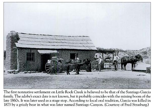
The Long Version: The first non-native settlement on Little Rock Creek is believed to be that of the Santiago Garcia family, descended from Mexican and native Californian ancestors. The head of the family was Santiago García, who was born circa 1833. He built an adobe which stood on a bench on the north side of Little Rock Creek approximately one-half mile to the east of where the creek turned from north to east at where the San Andreas fault system forced water to the surface, a cienaga. Cienaga meaning "swamp" or "drowned land" referred to as the "Garcia cienaga". The exact date of the construction of the adobe is not known, but most likley dates from the mining booms of the 1860s. In 1870 Garcia was settled at the cienaga, as indicated by the 1870 U.S. Decennial Census, as well as by local oral tradition. He was listed in that document as a farmer by occupation, with a net worth estimated at $450. He had apparently constructed a head gate on Little Rock Creek adjacent to his property, as indicated on a sketch map dating from the 1890s (Lownes n.d.). This indicates that he was engaging in crop irrigation. His family, consisting of himself, his wife
Catarina (30), his children Sanon (18), Eufracia (12), Isidoro (10), Octavia
(3), Santiago Garcia was killed in 1873 by a grizzly bear in what was later named Santiago Canyon, according to folklore by testimony of one of his descendants. He had wounded a grizzly in the canyon and had gone back to the area the next day to finish the animal off when he entered tall brush and was attacked. Family testimony indicates that a wagon was brought to take him down Soledad canyon to Los Angeles. Local oral tradition, however, states that he was buried in Little Rock Creek canyon somewhere near the site of the later dam. Garcia's family moved away from the area after his death. The Garcia adobe, however, remained. It is also said that the Garcia adobe served as a stop for stage and wagon traffic on what was later called the "Old Fort Tejon Road", which ran up the lower course of Little Rock Creek Canyon. From the Book "Images of Palmdale" Our local folklore also talks about a highway robbery man by the name of "Llargo" who held up a stagecoach on its way to San Francisco in the Little Rock cienaga vicinity. It's also said that Llargo took up residence in Garcia adobe at the cienaga , for how long, who knows. But the adobe it self was believed to be still standing in the 30's. |
||

 and Elasio (8 months), he also had two boarders, Gregorio Campos, (35),
who worked on the farm, and Manuel Feliz, (26), listed as a miner by
occupation. It is possible that the copper mining claims worked earlier in
the decade may still have been in operation, or the miner resident at the
Garcia cienaga may have had other jobs in the area.
and Elasio (8 months), he also had two boarders, Gregorio Campos, (35),
who worked on the farm, and Manuel Feliz, (26), listed as a miner by
occupation. It is possible that the copper mining claims worked earlier in
the decade may still have been in operation, or the miner resident at the
Garcia cienaga may have had other jobs in the area.|
Alpine Springs & Terra Bonita: The area had been mined and it's said that the first settlers had sheep, and it could also be farmed. So there was a big interest in diverting water from the Little Rock Creek. After the initial settlement of the Garcia cienaga, a second attempt was made to divert water from Little Rock Creek by a pair of promoters named Bent and Rowan, in circa 1885, who installed a head gate on the creek just below the Garcia head gate. In the late 1880s the Alpine Springs Land and Water Company was formed by the Cole Brothers, Charles, Zack, and Nathan, and Charles Cole's son, engineer Burt Cole. They had developed plans to found a colony at the mouth of Little Rock Creek canyon. They had originally set up a horse farm in the area, but became intrigued by the potential for establishing orchards there. The Coles then proceeded to convince land buyers and homesteaders in the lower Little Rock Creek area to petition Los Angeles County to form a Wright Act Irrigation District. This was accomplished in 1892. A similar district had been formed on Big Rock Creek with a view to water diversion there. In circa 1893, the Coles involved the firm of Palmer and Chapin of Chicago in promoting the Tierra Bonita Colony on the east bank of Little Rock Creek. This agricultural colony was laid out in the vicinity of the northern 'suburbs' of modern town of Little Rock. The Little Rock Creek Irrigation District was to maintain a head gate on Little Rock Creek and a supply ditch on the east bank of the creek that would provide irrigation water to this colony. At this time the first efforts were being made among settlers in the Little Rock area to develop pear production. Figs and almonds had been tried first, and then prunes and apricots, but pears would prove to be a success.
|
From the Book "Images of Palmdale"
|
